The Great Canadian Cycling Adventure
Across Canada by Bicycle in the Tour du Canada 2000
Welcome > Over the Rockies > Foothills to Prairies
Over the Rockies: Sicamous BC to Banff AB
Day
8: Sicamous to Albert Canyon, BC
"There's a time for some things, and a time for all things; a time for great things, and a time for small things." Miquel de Cervantes
This
morning dawned bright with the promise of a good day. Jules and I are the first to leave camp at 7:50 a.m., seeking
less traffic, no wind and an easy day. Our
route today will take us from Sicamous, on the TCH (Trans-Canada Highway) at the
northern gateway to the Oakanagan Valley, through the Monashee Range via the
Eagle Pass, over the Columbia River at Revelstoke, and then into the Selkirk
Range.
As
we spin easily along the TCH eastbound, I think about yesterday's rest day.
It was a good time to get caught up on a number of things.
I wrote some postcards, to be mailed today in Revelstoke, sent off my
journals to date via email, and repaired my bike.
The quote yesterday about bicycle maintenance is so true -- on this trip
they need daily attention to avoid surprises.
I'd been noticing for the last three days that I'd inflate the rear tire
to 120 psi each morning, yet at the end of the day it'd be at 80 psi. It wasn't dropping below 80 psi, but was likely on the verge
of flatting from something small poking the tube.
I took off the tire and tube and inspected them thoroughly.
I removed a small chunk of glass that had cut through the rubber and just
barely through the kevlar liner, but hadn't punctured the tube yet.
There's one flat avoided. Putting
the tube in water, I also found a very small leak.
Checking the tire at that spot, I pull out a piece of an ordinary office
staple about a third of a cm long. It
had driven through the tire, but was firm enough to be self-sealing at about 80
psi. Another on-the-road repair
avoided. This is the kind of thing
everyone's dealing with daily. Just
about everyone spends quite a bit of time cleaning, repairing, adjusting and
inspecting their bikes. Without a
bike, there's no trip.
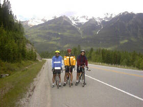
As
Jules and I spin along the TCH, early morning traffic is very light.
We stop to take pictures every once in a while.
Rounding one bend, we see the snow-covered peaks of the Monashee Range
come into view for the first time, and stop for more pictures.
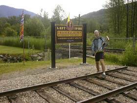
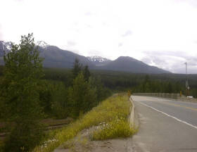
At 28 km into the day, we stop at Craigellachie. This is the site of the
driving of the "last spike" for the trans-continental Canadian Pacific
railroad in 1885. Again, more
pictures (see right), and we take some time for a food break too.
Hitting
the TCH again, about 53 km into the day we come to the Eagle Pass.
The history is that railway engineers searching for the best pass through
the Monashee Range shot at some eagles one day, the eagles took flight down the
valley, and the engineers followed them to discover the pass.
Hence, Eagle Pass. Just down
the road there's a beautiful lake, still in the morning air, and we stop to take
pictures of the peaks beyond perfectly silhoueted in the water.
A few kilometers down the road lies Three Valley Gap where the highway
partially circumnavigates an alpine lake with a lodge nestled at the head of the
lake, between two very steep mountain slopes that come right down to it's edges.
(picture left) 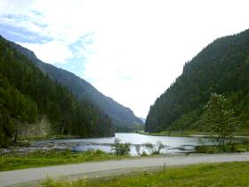 On
one side of the highway as we pedal along is the lake, and the other side, right
at our right elbows, goes straight up who knows how far.
There's lots of fallen rock debris along the shoulder we need to dodge,
and I can't help but worry about one of those "little" pieces falling
on me from hundreds of meters above.
On
one side of the highway as we pedal along is the lake, and the other side, right
at our right elbows, goes straight up who knows how far.
There's lots of fallen rock debris along the shoulder we need to dodge,
and I can't help but worry about one of those "little" pieces falling
on me from hundreds of meters above.
All
along this stretch of highway, the mountain slopes come right down to the
roadside. There are many creeks and
small waterfalls tumbling down the slopes.
Each one is frigid cold, carrying meltwater from snowfields high above.
The path that each one follows also carries a strong downdraft of frigid
air. The temperature is about 10C
colder as we pass each one.
Beyond
the Eagle Pass, we come to the outskirts of Revelstoke, at an altitude of about
560m. The sign says that the town's
altitude is 457m, so we know we've got a good descent coming.
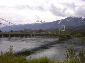
Sure enough, around a bend and down and down and down we go, scooting
across a suspension bridge over the Columbia River and into the Revelstoke
townsite.
Here
in Revelstoke we stop at a park beside the river for another lunch.
The Columbia River here is wide and deep, and running south with about a
15 knot current. The surface is
very smooth, leading me to think not only that this is a deep and powerful
river, but that it must truly be impressive several hundred kilometers
downstream where it approaches the ocean. From the park we can see the Monashee Range, with Mounts
Macpherson and Begbie prominent, on one side (picture right).
 That's the
range we've just come through. Ahead to the east loom the Selkirks. While the
Monashees appear to be upthrust "Rocky" type mountains, they're pretty
rounded compared to the more traditionally-thought of "Rockies" as
seen in the Selkirk Range. Up ahead
also are Mount Revelstoke, looming over the townsite, and beyond its national
park, Glacier National Park and Roger's Pass.
That's the
range we've just come through. Ahead to the east loom the Selkirks. While the
Monashees appear to be upthrust "Rocky" type mountains, they're pretty
rounded compared to the more traditionally-thought of "Rockies" as
seen in the Selkirk Range. Up ahead
also are Mount Revelstoke, looming over the townsite, and beyond its national
park, Glacier National Park and Roger's Pass.
We
spend some time exploring Revelstoke, checking in at the visitors' centre to
find directions to a camera shop. Like
most places we stop, the people are friendly and intrigued by our Tour du Canada
journey. Finding the camera shop,
Jules purchases some more film, and I managed to get a small screw to replace
one lost from my camera housing. The
woman in the store doesn't want payment for it, and wishes us well on our trip.
If you're in Revelstoke, check out the Revelstoke Camera House on
Mackenzie Ave. Not only is it a
helpful, fully stocked place, there is an amazing collection of mountain
photography taken by the proprietor. I
also manage to find a Canada Post mailbox and send off postcards written during
yesterday's stay in Sicamous. So
far I'm keeping up with journal and postcards -- we'll see how long I can keep
this up!
Leaving
Revelstoke, we're confronted with about an 8% grade to get back onto the TCH,
but once there we spin along nicely. We've
decided to take an easy pace today, and our average is only about 25 km/hr.
Even after the rest day, we're feeling the cumulative effects of cycling
over 700km in the last week. I've
got quads of jelly, and a very tender butt.
Don't know how long they'll take to get acclimatized, yet I'm thinking it
won't be until we're over the mountains and get another rest day in Drumheller!
 Along
the TCH, we stop at Skunk Cabbage Trail in Mount Revelstoke National Park, a
roadside picnic area and hiking trail. We
get some great pictures of the Illecillewaet River with the Selkirk peaks in the
background, and eat our third lunch for the day.
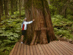
Two kilometers down the road we pull over to explore the Giant Cedars
Trail. There are two young Parks
employees there helping the busloads of people stopping, and they agree to watch
our bikes while we hike around the 0.5 km trail.
Entering the woods, it's like entering another world.
The vegetation is lush: undergrowth of huge ferns and moss-covered
deadfall muffles all noise. We're
surrounded by huge red cedars, hundreds of years old, some with trunks about 2m
in diameter. Of course we have to
take the obligatory "tree hugger" pictures (see right).
This trail is a highly recommended stop for anyone coming through this
region.
Along
the TCH, we stop at Skunk Cabbage Trail in Mount Revelstoke National Park, a
roadside picnic area and hiking trail. We
get some great pictures of the Illecillewaet River with the Selkirk peaks in the
background, and eat our third lunch for the day.
Two kilometers down the road we pull over to explore the Giant Cedars
Trail. There are two young Parks
employees there helping the busloads of people stopping, and they agree to watch
our bikes while we hike around the 0.5 km trail.
Entering the woods, it's like entering another world.
The vegetation is lush: undergrowth of huge ferns and moss-covered
deadfall muffles all noise. We're
surrounded by huge red cedars, hundreds of years old, some with trunks about 2m
in diameter. Of course we have to
take the obligatory "tree hugger" pictures (see right).
This trail is a highly recommended stop for anyone coming through this
region.
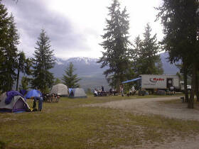
Down
the road a few more kilometers and we find Albert Canyon Hot Springs and our
campground for the night. Jules and
I are the first in camp, Brooke and the truck having arrived only about half an
hour ago. After setting up our
tents and getting things partially organized for tomorrow, we head off for
showers and a dip in the resort's hot mineral spring pool. The water is quite hot, and so very relaxing. After about 20
minutes, all I wanted was to be poured into my sleeping bag for the night.
 Once
again, the group enjoys a great dinner, and we all eat enough for an army.
Then it's time to check the bike, finish getting organized for tomorrow
morning, and make sure all foodstuffs
and toiletries are packed away in the truck.
This is bear country, and nothing that an inquisitive bear might
find attractive can be in a tent, or left on a bike.
All chores are now done, including this journal entry, just as the last
rays of the sun illuminate the very top of the snow-capped peak that looms over
the campground. Time for bed.
Tomorrow, after we leave the campground, we'll begin a long climb up to
and over Rogers Pass on our way to Golden, BC.
The campground is at about 600m, and the pass is at 1327m, so we've got
some massive climbing to do. Yep,
9:00 p.m., time for bed.
Once
again, the group enjoys a great dinner, and we all eat enough for an army.
Then it's time to check the bike, finish getting organized for tomorrow
morning, and make sure all foodstuffs
and toiletries are packed away in the truck.
This is bear country, and nothing that an inquisitive bear might
find attractive can be in a tent, or left on a bike.
All chores are now done, including this journal entry, just as the last
rays of the sun illuminate the very top of the snow-capped peak that looms over
the campground. Time for bed.
Tomorrow, after we leave the campground, we'll begin a long climb up to
and over Rogers Pass on our way to Golden, BC.
The campground is at about 600m, and the pass is at 1327m, so we've got
some massive climbing to do. Yep,
9:00 p.m., time for bed.
Daily
Stats:
Day
temp: 12C in
morning, about 18C at campground in the early evening.
Wind:
None until last
stretch into camp, when we have a very light tailwind.
Official
distance: 112
km Distance
actually cycled: 112 km
Elevation:
344m at Sicamous, 600m at Albert Canyon campground.
...alan
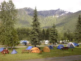
Canyon Hot Springs Resort
Albert Canyon Hot Springs,
on the Trans-Canada Highway between Mt Revelstoke and Glacier National Parks, BC
Day
9: Albert Canyon to Golden, BC
"It
is wonderful to feel the grandness of Canada in the raw, not because she is
Canada but because she's something sublime that you were born into, some great
rugged power that you are a part of." Emily Carr 1871-1945
Several
times last night I was awakened by rain on the tent -- not a welcome sign to be
sure. The morning dawns at 4:44
a.m. with a leaden sky and sodden ground and tent.
Fortunately, it's not raining as we chow
down on porridge, make our lunches, and head out on the highway again.
Jules and I leave at about 7:50 a.m., just like yesterday.
We're intent on taking our time and enjoying the lighter traffic earlier
in the morning. Jon left camp
before us, and we're sure we won't see him again until camp. He's young and strong, and rides like the wind, on a heavy
bike yet. Neri leaves before us as
well, and we think we'll catch up with him later in the day.
On the highway early in the morning, Jules and I find the traffic indeed very light -- only the occasional truck. The camper traffic doesn't really pick up until around 10 or 11 am. The morning temperature was 12C and it looked like rain, encouraging us to bring along our rain gear. We were also warned about a cold descent on the other side of Rogers Pass, so we brought along cold weather gear as well. We're carrying a lot of weight to lug up the hills!
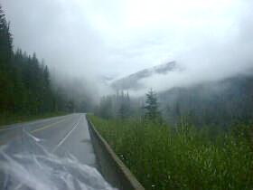
 We
spin along the TCH with low clouds scudding through the valley, below the
mountain tops which they hide. Not
long into our ride, it starts to rain and we stop to suit up with plastic bags
over our socks, neoprene overboots, leggings, helmet covers and rain jackets.
Hitting the road again, we're quite warm and comfortable.
We
spin along the TCH with low clouds scudding through the valley, below the
mountain tops which they hide. Not
long into our ride, it starts to rain and we stop to suit up with plastic bags
over our socks, neoprene overboots, leggings, helmet covers and rain jackets.
Hitting the road again, we're quite warm and comfortable.
We've
been climbing steadily, and a few kilometers from the summit the grade steepens
noticeably and the big climb begins. We
climb steadily for what seems forever -- around every curve there is more
hill and then another curve. Finally,
we crest the summit to see the Rogers Pass official site (picture below right)
and visitor centre. Cold and wet
through, we enter the visitor centre to see what's there and to get warmed up.
There are some historic and explanatory displays that show the
surrounding geography, and give one a sense of the massive and arduous task of
taking the railroads and highways through this area.
Heading over to the summit lodge we go inside where it's warm to enjoy
hot chocolate, pie and cinnamon buns. While
we're there, about half our groups straggles in, tired, wet and cold, yet
triumphant. 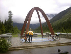
Going
outside again, we're instantly chilled in our wet clothes.
In addition to what I'm already wearing, I don a fleece helmet liner,
fleece gloves over my bike gloves, and a fleece vest under my jacket.
I'm as warmly dressed for the descent as I am when I go snowboarding! Back on the highway, we immediately start descending,
dropping from 1327m to 847m over several kilometers.
While the traffic isn't heavy, the descent is hazardous due to several
poorly illuminated showsheds along the way.
Snowsheds are simply roofed over sections of highway, abutting the cliff
wall on the mountain slope side, and supported by pillars on the downslope side.
These allow winter snowslides to simply pour over the highway without
blocking it. However, they're dimly lit, some are curved and long, and one
is pitch black. The snowsheds are
along the first part of the descent and we have to brake to about 50 km/hr to
feel comfortable going through them. We
make sure that there's no traffic behind us, and take the middle of the lane to
avoid the debris which is sure to be along the shoulder, and which we can't see
in the dark. Clear of the snowsheds,
the brakes come off and gravity does what it does best.
I pull ahead of Jules as I tuck down low, touching 80.1 km/hr at one
point. Finally the highway levels
out again, and we pull over to meet Craig at the side of the road.
During
the descent, the temperature has climbed from 10C to 15C, and we need to shed
all the heavy clothes before continuing. We
also meet up with John and Karin along the way, and we stop at the eastern gate
to Glacier National Park for some lunch and a rest before continuing.
Along this stretch we begin climbing again!
I thought we were done climbing for today!
We climb all the way back up to 1080m crossing the last mountain saddle,
and then plunge for several kilometers down a 6% to 8% grade to the Columbia
River. There's a slight headwind
that counteracts gravity, and our speeds are limited accordingly. Oh well! It's
still a wild ride down.
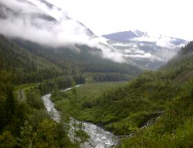
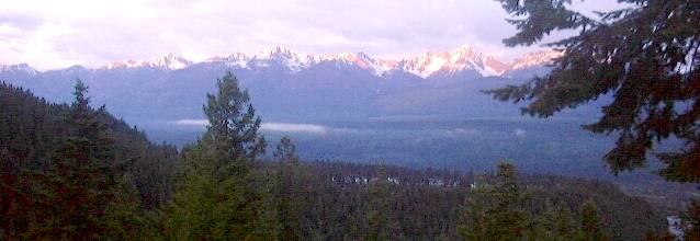
 Crossing
the river, we pull over for a rest, and look back and up at the Selkirk Range
we've just come through (picture left). We
can see the cut between the mountains we followed down, and the height from
which we've descended is truly an awesome site.
We just crossed through those mountains!
Crossing
the river, we pull over for a rest, and look back and up at the Selkirk Range
we've just come through (picture left). We
can see the cut between the mountains we followed down, and the height from
which we've descended is truly an awesome site.
We just crossed through those mountains!
We're
now in the Columbia River basin. The
river here is flowing northward from it's origin in the Columbia Icefield not
far to the south. From here it
flows north before looping westward around the top of the Selkirk Range and then
flowing south through Revelstoke and beyond.
The river is a milky green colour, heavy with silt from the glaciers that
spawned it.
The
final 14 km to Golden are pretty well flat, following the river valley all the
way. Karin and John peel off down a
side road in search of more drinking water, and Craig, Jules and I continue.
We've gone about 98 km at this point, and I'm pretty much exhausted.
Only the exhilaration of crossing the mountains counteracts wanting to
lie down at the side of the road and snooze for a while.
Craig is still feeling strong, and he pulls Jules and I along the highway
at 35 to 40 km/hr, assisted by a light tailwind.
Entering
Golden, the first thing we spot is a Dairy Queen, where we have to stop to
reward ourselves for our accomplishments of the day. Leaving the DQ, we know we've got about 2km and one hill to
go to the campground. What we
didn't know was that the hill is at least a 6% grade!
We finally hit the campground. Brook
and Jon are here ahead of us -- no surprise there.
We've also changed time zones, gaining an hour.
Time for a shower, laundry, dinner and bed!
 I
think that today was perhaps the toughest day yet, combining steep climbs,
perilous descents, some bad weather, and a longer distance.
It's made tougher by the "quads of jelly" that I'm sure won't
have a chance to feel better for many many days.
Yet, this challenge is what I was seeking in this trip, and looking up at
the Selkirks and the Columbia Mountains, and seeing the visual proof of what
we've done today, I'm amazed, humbled and energized.
I
think that today was perhaps the toughest day yet, combining steep climbs,
perilous descents, some bad weather, and a longer distance.
It's made tougher by the "quads of jelly" that I'm sure won't
have a chance to feel better for many many days.
Yet, this challenge is what I was seeking in this trip, and looking up at
the Selkirks and the Columbia Mountains, and seeing the visual proof of what
we've done today, I'm amazed, humbled and energized.
Daily
Stats:
Day
temp: 12C in
morning, 10C at Rogers Pass, 15C at end of descent from pass, 20C in Golden
Wind:
Variable: some
headwinds on descent from Rogers; tailwing into Golden
Official
distance: 118
km Distance
actually cycled: 118.7 km
Elevation:
600m at Albert Canyon, 1327m at Rogers Pass, 900m at Golden campground.
...alan
Whispering Spruce Campground,
Golden, BC
Day
10: Golden to Field, BC
"You
never conquer a mountain. You stand on the summit a few moments; then the wind
blows your footprints away." Arlene
Blum
Even
though we've just put the clocks ahead an hour to Mountain Time, I'm awake with
the sunrise and the birds, just in time to see the snow-capped peaks of the
Selkirk Range across the Columbia River valley
be illuminated with the first pink-orange rays of the sun.
I shiver as I watch the sunlight slowly caress it's way down the mountain
slopes, and the few clouds turn from orange to gray to white.
It's 10C, and it feels cold this morning.
We've
got a shorter (but tough!) distance to cover today, and people are slow in
rising. Kelly and John are on
breakfast duty, minus Eric. Eric
took a trip to the hospital last night to have a dislocated shoulder fixed.
This is a common occurrence for him, and he's soon up and ready to ride.
A few of us chip in to help get breakfast rolling, and before long we're
enjoying hot coffee, hot chocolate, hot oatmeal with apples, and cold cereal.
We all make our lunches (ever-present bananas and PBJs) and get set to
head out.
Jules
and I head out together again, leaving at 7:30 a.m. ahead of most of the group.
We're enjoying riding together -- we're pretty evenly matched on the
flats, I'm a little faster on the descents, and Jules is a little faster on the
climbs.
Despite
the initial long climb right out of camp before we're even well warmed up, it's
a beautiful morning. There's no
wind, just a few scattered clouds, and very little traffic yet.
Our route today takes us along the Trans-Canada Highway from Golden to
Field, just a few kilometers short of the Kicking Horse Pass which is also where
we cross the Great Divide and the BC-Alberta border.
 The
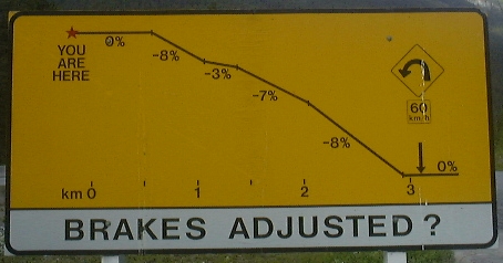
first 18 kilometers is pretty much all uphill, with only a few descents.
At 12 km out of Golden, we go up a 3 km climb with an average grade of
5.2%. In two sections it's an 8%
climb, and I've got a picture of the downbound-side warning sign for truckers to
prove it. This is a tough one --
with my gearing I'm pushing a 39-25 ratio at 50 rpm, doing about 10 klicks,
heartrate at 160 to 165, respiration deep and rapid.
Thinking back to sessions on instrumented exercise bikes, I'm burning
about 15 calories each minute on this accursed hill!
Maybe we should measure hills in bananas -- this would surely be a
"three banana hill". This
is tough going! As we crest the
hill, I stop to take the "prove it" picture at the "truckers
check your brakes" stop on the downbound side, and then we're on our way.
The
first 18 kilometers is pretty much all uphill, with only a few descents.
At 12 km out of Golden, we go up a 3 km climb with an average grade of
5.2%. In two sections it's an 8%
climb, and I've got a picture of the downbound-side warning sign for truckers to
prove it. This is a tough one --
with my gearing I'm pushing a 39-25 ratio at 50 rpm, doing about 10 klicks,
heartrate at 160 to 165, respiration deep and rapid.
Thinking back to sessions on instrumented exercise bikes, I'm burning
about 15 calories each minute on this accursed hill!
Maybe we should measure hills in bananas -- this would surely be a
"three banana hill". This
is tough going! As we crest the
hill, I stop to take the "prove it" picture at the "truckers
check your brakes" stop on the downbound side, and then we're on our way.
We've
now entered the Kicking Horse River valley, which we'll follow the remaining 45
km to Field. The Kicking Horse
river is clearly well below its flood level, with large gravel banks covered
with detritus as evidence. The
river is swift running, with rapids along long stretches of it, and it's a
pearlescent, milky green colour from the glacial silt it carries.
A
few kilometers up the road we meet up with Craig, and we all put some warmer
jackets on. While we're stopped, a
woman pulls up in a car on the other side of the road, gets out and crosses to
talk. She's with Randonneurs
Canada, and is acting as one of the escort vehicles for a fellow who's trying to
set a record for Calgary to Vancouver. This
cyclist holds the current record of something like 41 hours, and is out to do
the Calgary to Vancouver trip in 39 hours.
City centre to city centre by the most direct route along the TCH is 1057
km. If he makes it in 39 hours,
that's an average cycling speed of 27 km/hr. Not only is that a fast average speed for a
solo cyclist, he's going over the mountains, and he has to ride pretty-well
non-stop to do it. He left Calgary
at 1 am this morning! As we cycle
down the highway, we finally spot him and his support van coming the other way.
We shout and cheer him on as he passes us in a tight tuck. This guy has been
riding for about 8 hours solid at this point, and he's still motoring along.
And people think we TDC riders are crazy!!!
I'm
running out of superlatives to describe the scenery around us.
We're in the Rocky Mountains proper now, and their towering majesty is
unique from all the other ranges we've been through.
These are strong upthrust mountains, with sometimes castle-like
sedimentary layer-cake towers on top, sometimes sharply pointed and jagged
ridges of angled shales. We pass immense sheets of shale and other layered rock
structures. Sometimes the layers are level, sometimes on huge angles, testament
to the twisting and torturing this earth has seen through the ages.
From the peaks, the mountainsides are heavily wooded with mostly spruce,
the wooded areas split by chutes, many of them with frigid streams tumbling down
from still-melting snow fields. Each
stream that comes down to the roadside carries along with it a downdraft of
fresh frigid air from 1,000 to 1,300m above.
 Along
one such scenic stretch, we stop for one of our many PBJ & banana breaks.
As we sit at the side of the road, Brook bombs by in the truck, slows and
stops, and gets out to chat. We
take pictures of each other (see right), and then she's on her way and we are
too.
Along
one such scenic stretch, we stop for one of our many PBJ & banana breaks.
As we sit at the side of the road, Brook bombs by in the truck, slows and
stops, and gets out to chat. We
take pictures of each other (see right), and then she's on her way and we are
too.
Just
west of Field, on one of our many picture-taking stops, Craig decides that this
might be the last opportunity for a dip in the water in British Columbia.
In he wades, knee deep, in the icy cold torrent.
My thermometer says the water temperature is 7C -- that's cold!
With Craig's feet nicely refreshed, we spin along the flats of the
Kicking Horse River valley the final few kilometers to Field.
Entering
Field, it's time for a stop at the Visitor Centre first, for postcards, to look
around and check out maps and weather forecasts, and get directions to local
eateries. Jules and I have a
craving for a hamburger, and we're directed to the Truffle Pig Cafe down a
little side street. On our way
through town, we're joined by Daphne, Karin and John, and as we arrive, Dave,
Carol and Robert join too. 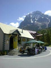 Jules
and I order bacon-cheeseburgers, served on bagels, while the rest order a
variety of Truffle's delights. Sitting
in the bright sun, nice and warm for a change, in this quiet little town, with
the hulking heights of Mt Stephen watching over us, life couldn't be better!
Jules
and I order bacon-cheeseburgers, served on bagels, while the rest order a
variety of Truffle's delights. Sitting
in the bright sun, nice and warm for a change, in this quiet little town, with
the hulking heights of Mt Stephen watching over us, life couldn't be better!
Although
we could sit here all afternoon, enjoying glasses of wine in the afternoon
sunshine, Craig and I set out for the final couple of kilometers to camp.
Just across the highway from the campground entrance is one of the
portals of the railroad spiral tunnel. Trains
cannot handle a grade greater than about 2%.
In order to gain the elevation needed to get through the Kicking Horse
Pass -- about 400m from Field to the pass in about 13 km, or an average grade of
3% -- the trains take an immense spiral tunnel through the mountainside to
smooth out the grade.
This
is a great campground. We're in
Yoho National Park. Although there's no electrical hookup, the campground is
well away from most highway and railroad noise -- the first time since leaving
Vancouver! The sun is out, it's
hot, camp is all set up, and it's time to work on my journal.
While writing this, some rainshowers move through and cool things off
nicely. They're not persistent, passing quickly. The same is forecast
for tomorrow.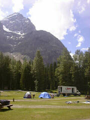
In
the morning we'll set out for Banff. We're
going to climb the 400m in 13 km from here to the Kicking Horse Pass, where
we'll stop to take pictures, note our entry into Alberta, celebrate our exit
from British Columbia, and head downhill toward the Bow Valley and our route to
Banff and later, out to Calgary. It's
about an 80+ km day tomorrow -- not a bad distance except for the initial climb
over the pass. Jules, Karin and I
are on cooking duty tomorrow night in Banff, so we'll try to get away early so
as to arrive in Banff early. We
also plan to stop at Lake Louise along the way (and endure the steep climb up to
the Lake from the highway) to sightsee and take yet more pictures.
What
a life! Our passing through this
way will leave no great nor lasting impression on those we encounter along the
way, or the countryside we travel through.
Yet, each of us is surely changed. At
times when I'm spinning along the roadside I feel like I could ride forever.
Seeing the country this way is at
times awe-inspiring, breath-taking and joyous.
At times I just have to ride along with my arms raised high in the air
and shout at the mountains; other times on fast descents, it's a Geronimo
war-whoop that matches my exhilaration. Other
times, I'm just overpowered by the immensity and beauty of the landscape, and
ride along with a catch in my throat and tears in my eyes.
This is Canada and how it's meant to be seen! And I'm cycling across the full breadth and diversity of this
great land. My name is Alan, and I'm cycling across Canada!
What a life!
Daily
Stats:
Day
temp: 10C in
morning, cooler spots along some river valleys, 20C in Field in afternoon
Wind:
Very light to
non-existent all day.
Official
distance: 66
km Distance
actually cycled: 60.8 km
Running
totals: Cycling
time: 37:28 hrs Distance
travelled: 970 km Avg
speed: 25.9 km/hr
Elevation:
900m at Golden camprground, 1260 at Field campground.
PBJs
consumed to date:
20 Bananas consumed to date: 32
...alan
Yoho National Park
Field, BC
Day
11: July 9, 2000, Field, BC to Banff, AB
"We
do not remember days; we remember moments." Cesare Pavese
The
angry sound of rain pelting my tent woke me up early this morning.
It went down to about 7C last night and it's cold and wet this morning.
Not an auspicious start for the day.
Anticipating the worst, or providing myself insurance, whichever flavour
fits, I dress fully for cold, wet weather: booties, leggings, polypro tops,
helmet cover and Gortex jacket. By the time lunches are packed and breakfast
finished, the rain has cleared and the sky provides a hint of better weather
coming.
Jules
and I hit the road a few minutes later, and make our way out of the campground
and onto the TCH for the climb to Kicking Horse Pass. The climb starts immediately, not even giving us a chance to
warm up first. The TCH here follows
the original railbed, so the grade is very consistent for about 8 km.
About halfway up, I'm getting overheated so stop to take off a layer and
stretch a little. Back on the bike,
I push up the rest of the grade. It's
another good aerobic workout!
Just
before the crest, we take the turnout to the Lake Ohara hiking trails.
One of the trails is actually the old highway, still in good shape for
cycling. This is our route for the
day, even though the sign says, "Closed."
However, we've learned to trust Bud's maps, so off we go down the road. 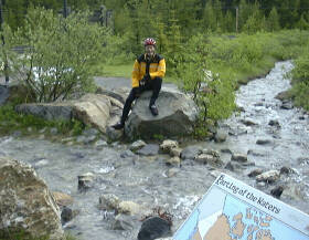 Karl
and Jon have just caught up with us and we travel together for the rest of the
day. After a bit of climbing along
this twisting old road, we come to the Great Divide.
This is truly an occasion. We
take a bunch of photos of everyone, and walk down a trail to see the stream that
divides and then runs off in two directions. (see picture right) The western leg is headed for the Pacific Ocean 1950km away.
The eastern leg is headed for the Atlantic Ocean via Hudsons Bay, 2550 km
away. A tinkle in the stream here
pollutes two oceans! Too cool!
Karl
and Jon have just caught up with us and we travel together for the rest of the
day. After a bit of climbing along
this twisting old road, we come to the Great Divide.
This is truly an occasion. We
take a bunch of photos of everyone, and walk down a trail to see the stream that
divides and then runs off in two directions. (see picture right) The western leg is headed for the Pacific Ocean 1950km away.
The eastern leg is headed for the Atlantic Ocean via Hudsons Bay, 2550 km
away. A tinkle in the stream here
pollutes two oceans! Too cool!
We're
done with BC now, and into Alberta! Continuing
on the old highway, it actually continues to climb, and brings us out onto the
Lake Louise road, about 3/4 of the way up the hill from the village to the
Chateau Lake Louise. We climb the
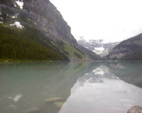
hill to the Chateau, lock up our bikes, take lots of pictures (see below left)
and a tour around the hotel, and pause for coffee, hot chocolate and cinnamon
buns and the like. While there,
Karin and John roll in too.
 Leaving
Lake Louise, we head down the steep hill to the village.
Gravity does it's thing again, and I run out the bottom few curves
coasting at 78.6 km/hr, whooping aloud all the way!
Crossing the TCH, we take Hwy 1A, the "Banff Parkway", which is
a pleasant ride free of trucks, and only little camper traffic to worry
about. We pass the Lake Louise ski
area, looking strange with snow only on a few of the higher runs.
Leaving
Lake Louise, we head down the steep hill to the village.
Gravity does it's thing again, and I run out the bottom few curves
coasting at 78.6 km/hr, whooping aloud all the way!
Crossing the TCH, we take Hwy 1A, the "Banff Parkway", which is
a pleasant ride free of trucks, and only little camper traffic to worry
about. We pass the Lake Louise ski
area, looking strange with snow only on a few of the higher runs.
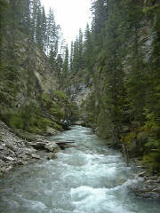
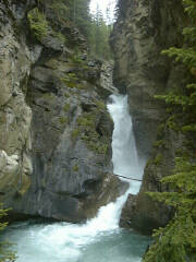
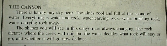
The four of us form a paceline and zip along, rotating the lead often. When cycling, we're tooling along between 37 and 48 km/hr. However, we do take lots of stops to take pictures, eat bananas and PBJ, look at the scenery, and chat with people at the stops along the way. About 23 km from Banff we stop at the Johnson Canyon area to take the 1.5 km hike up the canyon. The canyon is a very narrow water-cut rift in the rock, riven by the tumbling little river that runs a clear, milky blue colour. It's quite a scenic diversion.
Back
on our bikes, we push really hard in a peloton for the 17 km down the rest of
the Banff Parkway to where it meets up with the TCH. At the interchange, there's a "texas gate".
This is grating of steel cylinders with big spaces between, running
across the road and intended to keep wildlife from venturing onto the highway.
It's impossible to cycle across without a serious fall, and forwarned, we
dismount and walk across.
 The
final 5 km into Banff is another fast paceline ride, and we take the exit from
the TCH into the townsite, only to be immediately snared in tourist gridlock
throughout the entire town. We part
ways here, some to the liquor store, and I to the bike store to find some arm
and leg warmers. Mission
successful, I find my way to the campground area and find the truck.
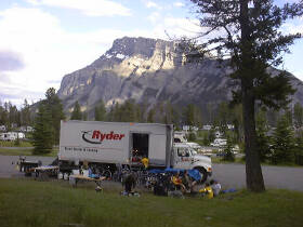
This is not the greatest campground setup; the group tenting area is
about 100m up a hill away from the truck, and we're in bear country, so no
toiletries or foodstuff in the tents.
The
final 5 km into Banff is another fast paceline ride, and we take the exit from
the TCH into the townsite, only to be immediately snared in tourist gridlock
throughout the entire town. We part
ways here, some to the liquor store, and I to the bike store to find some arm
and leg warmers. Mission
successful, I find my way to the campground area and find the truck.
This is not the greatest campground setup; the group tenting area is
about 100m up a hill away from the truck, and we're in bear country, so no
toiletries or foodstuff in the tents.
Jules,
Karin, Daphne and I are on galley duty, and we make a feast of spaghetti with
meat sauce, salad nicoisse and serve it with wine to toast and celebrate our
passage through the mountains and BC. After cleanup and chores, we prep some
stuff for breakfast. Tomorrow's an
early start for the nearly 200 km ride to Beiseker, NE of Calgary.
And, it's getting darn cold sitting here typing at 9:30 pm. I'm going to
bed!
Daily
Stats:
Day
temp: 10C at
campsite in morning and through most of day; about 15C at campsite in
afternoon
Wind:
none
Official
distance: 83 km
Distance actually cycled:
94.8 km
Elevation:
1260 at Field campground to 1650m at Kicking Horse Pass, to 1732 m at Lake
Louise, and down to about 1350m at Banff
PBJs
consumed to date: 22
Bananas consumed to date: 35
...alan
Tunnel Mountain Campground,
Banff, Alberta
Welcome > Over the Rockies > Foothills to Prairies